Planning openbare ruimte Oostenburg
New Information on Oostenburg Public Space Planning Now Available on Oostenburg.nl
🔧 Step-by-step development
The public space on Oostenburg is being developed step by step. Some streets are already fully completed and have been handed over to the City of Amsterdam. Other streets are still under construction. In those areas, you’ll still find so-called “construction roads”: temporary roads that are not yet in their final layout.
Although these construction roads are not finished, they are public and accessible to residents and visitors. This results in a temporary situation where some streets look neat and complete, while others still have a rougher appearance.
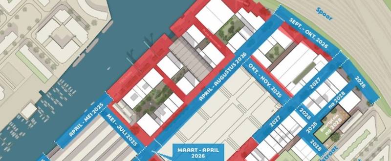
🗺️ Progress overview
The map on the Oostenburg website shows:
-
Which streets are finished (marked in red)
-
Where work is still ongoing (blue)
-
What work is planned for each street
This schedule is indicative. Unexpected circumstances may cause delays.
The rough phasing of the work is as follows:
-
Area around the Van Gendthallen – planned for 2025
-
Connecting road Oostenburgermiddenstraat – planned for 2026
-
Area around the neighborhood square – planned for 2028
Note: This overview only concerns the Oostenburg project. Work by other parties, such as ProRail or the future bicycle path along the railway, is not included.
🏘️ Over de Brug keeps you informed about local developments
Stichting Over de Brug closely monitors the progress of the redevelopment. We stay updated on what’s happening in the neighborhood, track the progress, and note any delays or changes in the schedule.
Curious about the current status? Want to know how the work might affect your street or route?
👉 Visit our neighborhood room!
We’ll be happy to update you in person and help think through practical solutions.
📖 More information
Want to see the full planning overview yourself? Click here:
Read the original post